
Access points on the ARWT map
Last update: 2026-07-15
Suggest changes, additions, etc. in pictures or text through this form.
See also All points and Categories.
Summary Access Table
| ARWT Miles |
Access Point | Ramp | Launch | Amenities | Miles to Next |
Paddle Time |
Latitude, Longitude | Low | High | Gauge† |
|---|---|---|---|---|---|---|---|---|---|---|
| Alapaha River | ||||||||||
| 127.6 | Sheboggy Boat Ramp @ US 82, Berrien Co., GA |
 |
   |
6.11 | 3.1 | 31.386279, -83.191609 | 215.3 feet (7.7′) | 218.2 feet (10.6′) | Alapaha | |
| 121.49 | Rowetown Church Landing Berrien Co., GA |
 |
 |
12.96 | 6.5 | 31.3402, -83.150463 | 215.3 feet (7.7′) | 218.2 feet (10.6′) | Alapaha | |
| 108.53 | Nashville Landing @ GA 135, Berrien Co., GA1 |
|
|
0.02 | 0.0 | 31.301521, -83.054924 | 215.3 feet (7.7′) | 218.2 feet (10.6′) | Alapaha | |
| 108.51 | Willacoochee Landing @ GA 135, Atkinson Co., GA3 |
|
|
19.17 | 9.6 | 31.304338, -83.052555 | 215.3 feet (7.7′) | 218.2 feet (10.6′) | Alapaha | |
| 89.34 | Berrien Beach Boat Ramp @ GA 168, Berrien Co., GA |
|
|
16.77 | 8.4 | 31.159076, -83.045554 | 209.6 feet (2.0′) | 218.2 feet (10.6′) | Alapaha | |
| 72.57 | Lakeland Boat Ramp @ GA 122, Lanier Co., GA |
|
|
0.2 | 0.1 | 31.045456, -83.047068 | 78.1 feet (2.0′) | 85.1 feet (9.0′) | Statenville | |
| 72.37 | Pafford’s Landing Lanier Co., GA |
|
 |
1.77 | 0.9 | 31.043011, -83.042564 | 78.1 feet (2.0′) | 85.1 feet (9.0′) | Statenville | |
| 70.6 | Burnt Church Landing @ GA 135, Lanier Co., GA |
|
|
12.19 | 6.1 | 31.024737, -83.04895 | 78.1 feet (2.0′) | 85.1 feet (9.0′) | Statenville | |
| 58.41 | Hotchkiss Road Landing @ Hotchkiss Road, Lanier Co., GA |
|
|
1.11 | 0.6 | 30.93669, -83.0406 | 78.1 feet (2.0′) | 84.1 feet (8.0′) | Statenville | |
| 57.3 | Naylor Boat Ramp @ US 84, Lowndes Co., GA |
|
|
11.24 | 5.6 | 30.924282, -83.038427 | 78.1 feet (2.0′) | 83.1 feet (7.0′) | Statenville | |
| 46.06 | Mayday Landing @ Howell Road, Echols Co., GA |
|
|
14.55 | 7.3 | 30.82827, -83.017179 | 78.1 feet (2.0′) | 86.1 feet (10.0′) | Statenville | |
| 31.51 | Statenville Boat Ramp @ GA 94, Echols Co., GA |
|
|
10.36 | 5.2 | 30.704437, -83.03468 | 78.1 feet (2.0′) | 86.1 feet (10.0′) | Statenville | |
| 21.15 | Sasser Landing @ NW 72 Court, Hamilton Co., FL |
|
|
3.6 | 1.8 | 30.599562, -83.069828 | 65 feet (4.4′) | 76 feet (15.4′) | Jennings | |
| 17.55 | Jennings Bluff Launch @ NW 82 Court, Hamilton Co., FL |
 |
|
6.05 | 3.0 | 30.56716, -83.0391 | 65 feet (4.4′) | 76 feet (15.4′) | Jennings | |
| 11.5 | US 41 Alapaha River Landing Hamilton Co., FL |
|
|
11.53 | 5.8 | 30.528956, -83.039627 | 65 feet (4.4′) | 76 feet (15.4′) | Jennings | |
| Alapahoochee River | ||||||||||
| 10.82 | GA 376 Alapahoochee Landing Echols Co., GA |
|
|
3.54 | 1.8 | 30.70355, -83.12253 | ||||
| 7.28 | Culpepper Alapahoochee Landing Echols Co., GA |
|
|
4.54 | 2.3 | 30.673501, -83.103347 | ||||
| 2.74 | GA 135 Alapahoochee Landing Echols Co., GA |
|
|
2.83 | 1.4 | 30.62845, -83.0893 | 77.5 feet (1.4′) | 86.1 feet (10.0′) | Statenville | |
| Suwannee River | ||||||||||
| 135.4 | Gibson Park Ramp @ SW CR 751, Hamilton Co., FL |
|
 |
5 | 2.5 | 30.437637, -83.094031 | Ellaville | |||
| 130.4 | Suwannee River Campsites Ramp @ SW 46th Ave., Hamilton Co., FL |
|
|
2.7 | 1.4 | 30.414, -83.159167 | Ellaville | |||
| 127.7 | Suwannee River State Park Ramp @ 201st Path, Suwannee Co., FL |
|
   |
0.0 | 30.3877, -83.1688 | Ellaville | ||||
† Advisory estimates for feet above sea level (NAVD88) on the indicated Gauge of:
Low: lowest boatable without a lot of dragging; at or slightly above NWS Low Stage
High: highest safe; at or slightly below NWS Action Stage
1 For high water go to Willacoochee Landing @ GA 135 in Atkinson County.
2 For high water go to Willacoochee Landing @ GA 135 in Atkinson County.
3 For low water go to Nashville Landing @ GA 135 in Berrien County.
4 For low water go to Nashville Landing @ GA 135 in Berrien County.
5 https://maps.app.goo.gl/B5Sin57bTAnguWgs6
6 https://wwals.net/pictures/2021-07-08–sewage-spills-valdosta-starke
Distances between Access points
0.02 mile from Nashville Landing to Willacoochee Landing0.20 mile from Lakeland Boat Ramp to Pafford’s Landing
1.11 miles from Hotchkiss Road Landing to Naylor Boat Ramp
1.77 miles from Pafford’s Landing to Burnt Church Landing
2.70 miles from Suwannee River Campsites Ramp to Suwannee River State Park Ramp
2.83 miles from GA 135 Alapahoochee Landing to Sasser Landing
3.54 miles from GA 376 Alapahoochee Landing to Culpepper Alapahoochee Landing
3.60 miles from Sasser Landing to Jennings Bluff Launch
4.54 miles from Culpepper Alapahoochee Landing to GA 135 Alapahoochee Landing
5.00 miles from Gibson Park Ramp to Suwannee River Campsites Ramp
6.05 miles from Jennings Bluff Launch to US 41 Alapaha River Landing
6.11 miles from Sheboggy Boat Ramp to Rowetown Church Landing
10.36 miles from Statenville Boat Ramp to Sasser Landing
11.24 miles from Naylor Boat Ramp to Mayday Landing
11.53 miles from US 41 Alapaha River Landing to Gibson Park Ramp
12.19 miles from Burnt Church Landing to Hotchkiss Road Landing
12.96 miles from Rowetown Church Landing to Nashville Landing
14.55 miles from Mayday Landing to Statenville Boat Ramp
16.77 miles from Berrien Beach Boat Ramp to Lakeland Boat Ramp
19.17 miles from Willacoochee Landing to Berrien Beach Boat Ramp
Spreadsheet Details
Descriptions
Sheboggy Boat Ramp @ US 82

CATEGORIES: Landing
LAYER: Brochure
OWNERSHIP: Public
ACCESS: Yes, Ramp: Concrete on graveled access road, PARKING: Free, HANDICAPPED ACCESSIBLE
WATER BODY: Alapaha River
Lowest boatable: 215.3
Highest safe: 218.2
GAUGE: Alapaha
MILE: 127.60
ADDRESS: Left bank, 11004 US Highway 82, Alapaha, GA 31622, Berrien County.
DESCRIPTION: One of the longest downstream paddles, but well worth it to see why the Alapaha is rated A+ for scenery: overhanging oaks, pines, cypress, river birch, ogeechee limes, herons, bass, turtles, almost no invasive species, old railbridge pilings, a mystery church, power lines, and many creeks.
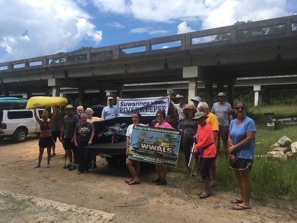
HISTORIC FACTS: Sheboggy is the traditional name for this Alapaha River access point, after the nearby Sheboggy Package Store, which is currently in ruins. At the request of WWALS, in March 2018 Berrien County officially renamed it Sheboggy Boat Ramp. https://wwals.net/?p=43927 Berrien County in June 2017 rebuilt Sheboggy Boat Ramp and improved the access road. https://wwals.net/?p=34422
AKA: Sheboggy Landing
WEBSITE: https://wwals.net/2018/09/23/wwals-cleanup-at-sheboggy-boat-ramp-us-82-alapaha-river-2018-09-09/
DOWNSTREAM: 6.11 miles from Sheboggy Boat Ramp to Rowetown Church Landing
PHOTO: https://wwals.net/wp-content/themes/pianoblack/img//2018/09/915c38119e112b7fb102a9abfc78c947.jpg
PHOTOSET: https://wwals.net/2018/09/23/wwals-cleanup-at-sheboggy-boat-ramp-us-82-alapaha-river-2018-09-09/
PHOTO SOURCE: Gretchen Quarterman
PHONE NUMBER: (850) 290-2350
PHOTO2: https://wwals.net/pictures/2020-09-26–drafts-metal-signs/Sheboggy-Boat-Ramp-ARWT-metal-sign-0001.jpg
PHOTO2 SOURCE: WWALS
Photo2 Phone Number: 850-290-2350
Suggestions: https://forms.gle/DipPgU2TP5atc2Rf9

Rowetown Church Landing

CATEGORIES: Landing Private Ask
LAYER: Brochure
GPS: 31.3402, -83.150463
OWNERSHIP: Private, Gaskins Timber & Wildlife LLLP, PARCEL 084 4 002
ACCESS: Ask, Launch: Grassy river bank on private long unpaved woods road back of cemetery. PARKING: Free
WATER BODY: Alapaha River
Lowest boatable: 215.3
Highest safe: 218.2
GAUGE: Alapaha
MILE: 121.49
ADDRESS: 1291 Rowetown Church Road, Alapaha, GA 31622, Berrien County.
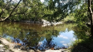
DESCRIPTION: Call 229-686-4512 for permission before using. It’s a long (500 feet), smooth, sloping access through the woods, but worth it for itself, and makes a downstream paddle from Sheboggy much more manageable. Long slope below historic cemetery. 7 miles east of Alapaha, GA via Moore Sawmill Road.
HISTORIC FACTS: The nearby Rowetown Church Cemetery dates back to the nineteenth century.
WEBSITE: https://wwals.net/2015/01/18/alapaha-river-deadfalls-outing-us82-south-wwals-2015-01-17/
UPSTREAM: 6.11 miles from Rowetown Church Landing to Sheboggy Boat Ramp
DOWNSTREAM: 12.96 miles from Rowetown Church Landing to Nashville Landing
PHOTO: https://wwals.net/wp-content/themes/pianoblack/img//2015/01/e268cf037394ee58f908d412f493a23e.jpg
PHOTOSET: https://wwals.net/2015/01/18/alapaha-river-deadfalls-outing-us82-south-wwals-2015-01-17/
PHOTO SOURCE: John S. Quarterman
PHONE NUMBER: (850) 290-2350
Suggestions: https://forms.gle/DipPgU2TP5atc2Rf9
Nashville Landing @ GA 135
*

CATEGORIES: Landing
LAYER: Brochure
OWNERSHIP: Public
ACCESS: Yes, Launch: Sand and gravel state highway abutment down dirt access road, PARKING: Free
WATER BODY: Alapaha River
Lowest boatable: 215.3
Highest safe: 218.2
GAUGE: Alapaha
MILE: 108.53
ADDRESS: 10921 GA 135, Nashville, GA 31639, Berrien County, right bank, west side of the bridge, northeast of Nashville, GA. Berrien County.
DESCRIPTION: Backwoods, no towns, almost no industry: just pines, cypress, river birch, tupelo, fish, birds, and turtles, with a railroad bridge and some creeks: an excellent all-day downstream paddle, although it really will take all day at low water. * For high water go to Willacoochee Landing @ GA 135 in Atkinson County. For low water. Berrien County side of the bridge. GPS at the river: 31.303278, -83.05391.
AKA: GA 135 Berrien
WEBSITE: http://alltrails.com/trail/us/georgia/alapaha-river-ga-135-to-fl-150
UPSTREAM: 12.96 miles from Nashville Landing to Rowetown Church Landing
DOWNSTREAM: 0.02 mile from Nashville Landing to Willacoochee Landing
PHOTOSET: https://wwals.net/2014/12/08/alapaha-river-ga-135-berrien-county-south-willacoochee/
PHOTO SOURCE: Bret Wagenhorst
PHONE NUMBER: (850) 290-2350
PHOTO2: https://wwals.net/pictures/2020-09-26–drafts-metal-signs/Nashville-Landing-ARWT-metal-sign-0001.jpg
Photoset2: https://wwals.net/pictures/2020-09-26–drafts-metal-signs/Nashville-Landing-ARWT-metal-sign-0001.html
PHOTO2 SOURCE: WWALS
Photo2 Phone Number: 850-290-2350
Suggestions: https://forms.gle/DipPgU2TP5atc2Rf9

Willacoochee Landing @ GA 135
*

CATEGORIES: Landing
LAYER: Brochure
OWNERSHIP: Public
ACCESS: Yes, Launch: Sand and gravel state highway abutment, PARKING: Free
WATER BODY: Alapaha River
Lowest boatable: 215.3
Highest safe: 218.2
GAUGE: Alapaha
MILE: 108.51
ADDRESS: GA 135, left bank, west side of the bridge, Atkinson County side, 2.8 miles south of Willacoochee, GA, Atkinson County.
DESCRIPTION: Very long, but well worth it, for pines, cypress, river birch, tupelo, bass and catfish, herons, and turtles, with a railroad bridge and some creeks: an excellent all-day high-water paddle. * For low water go to Nashville Landing @ GA 135 in Berrien County. For high water. Atkinson County side of the bridge. GPS at the river: 31.3032169, -83.05335.
AKA: GA 135 Atkinson
WEBSITE: https://wwals.net/pictures/2016-02-20–wwals-alapaha/
UPSTREAM: 0.02 mile from Willacoochee Landing to Nashville Landing
DOWNSTREAM: 19.17 miles from Willacoochee Landing to Berrien Beach Boat Ramp
PHOTO: https://wwals.net/pictures/2016-02-20–wwals-alapaha/before-crop.jpg
PHOTOSET: https://wwals.net/pictures/2016-02-20–wwals-alapaha/before-crop.html
PHOTO SOURCE: Gretchen Quarterman
PHONE NUMBER: (850) 290-2350
PHOTO2 SOURCE: WWALS
Photo2 Phone Number: 850-290-2350
Suggestions: https://forms.gle/DipPgU2TP5atc2Rf9

Berrien Beach Boat Ramp @ GA 168

CATEGORIES: Landing
LAYER: Brochure
OWNERSHIP: Public, Langdale Timber Company, PARCEL 114 1 000
ACCESS: Yes, Ramp: Concrete on state highway right of way, PARKING: Free, HANDICAPPED ACCESSIBLE
WATER BODY: Alapaha River
Lowest boatable: 209.6
Highest safe: 218.2
GAUGE: Alapaha
MILE: 89.34
ADDRESS: 12496 GA 168, Nashville, GA 31639, N side of GA 168, right bank, west side of Alapaha River. Berrien County.
DESCRIPTION: Float downstream under the bridge to the sand beaches of Berrien Beach. When there is enough water, take a nice long winter all-day paddle, with sites of two railbridges, many white sand beaches, river birch, cypress, pines, oaks, tupelo, fish, birds, turtles, creeks, and cut-throughs at high water. The boat ramp is public, but the Berrien side of the river is owned by Langdale Timber Company. GPS at the river: 31.1571, -83.0396
HISTORIC FACTS: Ramp rebuilt in September 2020 by Berrien County with assistance of the Georgia Department of Natural Resources (GA-DNR).
AKA: Berrien Beach Landing
UPSTREAM: 19.17 miles from Berrien Beach Boat Ramp to Willacoochee Landing
DOWNSTREAM: 16.77 miles from Berrien Beach Boat Ramp to Lakeland Boat Ramp
PHOTO: https://wwals.net/wp-content/themes/pianoblack/img//2017/02/8536f1f98878228d3b6a43891a0d8089.jpg
PHOTO SOURCE: John S. Quarterman
PHONE NUMBER: (850) 290-2350
Photoset2: https://wwals.net/pictures/2020-09-26–drafts-metal-signs/
PHOTO2 SOURCE: WWALS
Photo2 Phone Number: 850-290-2350
Suggestions: https://forms.gle/DipPgU2TP5atc2Rf9

Lakeland Boat Ramp @ GA 122

CATEGORIES: Landing
LAYER: Brochure
OWNERSHIP: Public, Highway right of way
ACCESS: Yes, Ramp: Concrete down gravelled access road on state highway right of way. PARKING: Free, HANDICAPPED ACCESSIBLE
WATER BODY: Alapaha River
Lowest boatable: 78.1
Highest safe: 85.1
GAUGE: Statenville
MILE: 72.57
ADDRESS: South side of GA 122 and GA 37, right bank, west side of Alapaha River. Lanier County.
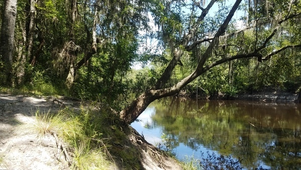
DESCRIPTION: Plenty of swimming, fishing, and sand lunch beaches downstream from here. Scout The Rocks before shooting: the difficulty of those rapids varies widely with water level. In the wildwood in the spring you may see resurrection fern or red Ogeechee limes. GPS at the river: 31.04585, -83.04352.
AKA: Lakeland Bridge, GA 122 Lakeland, GA 122 Alapaha River.
WEBSITE: https://www.lakelandchamber.org/parks–trails.html
ADDITIONAL INFO SOURCES: https://www.theswimguide.org/beachmanager/beaches/view?id=10196
UPSTREAM: 16.77 miles from Lakeland Boat Ramp to Berrien Beach Boat Ramp
DOWNSTREAM: 0.20 mile from Lakeland Boat Ramp to Pafford’s Landing
PHOTO: https://wwals.net/pictures/2020-09-12–wq/20200912_121858.jpg
PHOTOSET: https://wwals.net/pictures/2020-09-12–wq/
PHOTO SOURCE: John S. Quarterman
PHONE NUMBER: (850) 290-2350
PHOTO2: https://wwals.net/pictures/2020-09-26–drafts-metal-signs/Lakeland-Boat-Ramp-ARWT-metal-sign-0001.jpg
PHOTO2 SOURCE: WWALS
Suggestions: https://forms.gle/DipPgU2TP5atc2Rf9

Pafford’s Landing

CATEGORIES: Landing Private
LAYER: Brochure
OWNERSHIP: Private, Lanier Parks, Inc. A GA nonprofit corp. with J. Wendell Goodbee as CEO and CFO and Nell P. Roquemore as Secretary. https://cgov.sos.state.ga.us/Account.aspx/ViewEntityData?entityId=882112, PARCEL 030 0038B
ACCESS: Yes, Launch: sand beach down long dirt road. CAMPING, PARKING: Free
WATER BODY: Alapaha River
Lowest boatable: 78.1
Highest safe: 85.1
GAUGE: Statenville
MILE: 72.37
ADDRESS: South side of GA 122 and GA 37, into the woods, right bank, west side of Alapaha River. Lanier County.
DESCRIPTION: Sand beach in privately-owned park open to the public. Scout The Rocks before shooting: the difficulty of those rapids varies widely with water level. In the wildwood in the spring you may see resurrection fern or red Ogeechee limes. Plenty of swimming, fishing, and sand lunch beaches.
AKA: Blue Hole or Paffords Landing.
WEBSITE: https://wwals.net/2017/08/25/paffords-landing-alapaha-river/
UPSTREAM: 0.20 mile from Pafford’s Landing to Lakeland Boat Ramp
DOWNSTREAM: 1.77 miles from Pafford’s Landing to Burnt Church Landing
PHOTO: https://wwals.net/wp-content/themes/pianoblack/img//2017/08/63af980d816cda40380781be5a81ec91.jpg
PHOTOSET: https://wwals.net/2017/08/25/paffords-landing-alapaha-river/
PHOTO SOURCE: John S. Quarterman
PHONE NUMBER: (850) 290-2350
PHOTO2: https://wwals.net/pictures/2020-09-26–drafts-metal-signs/Paffords-Landing-ARWT-metal-sign-0001.jpg
Photoset2: https://wwals.net/pictures/2020-09-26–drafts-metal-signs/Paffords-Landing-ARWT-metal-sign-0001.html
PHOTO2 SOURCE: WWALS
Suggestions: https://forms.gle/DipPgU2TP5atc2Rf9

Burnt Church Landing @ GA 135
CATEGORIES: Landing
LAYER: Brochure
GPS: 31.024737, -83.04895
OWNERSHIP: Public, Lanier Co. Board of Commissioners, PARCEL 031 0038
ACCESS: Yes, Launch: sand beach below steep riverbank. PARKING: Free
WATER BODY: Alapaha River
Lowest boatable: 78.1
Highest safe: 85.1
GAUGE: Statenville
MILE: 70.60
ADDRESS: 217 Burnt Church Road (GA 135), Lakeland, GA 31635, right bank, west side of river, 3 miles southeast of Lakeland, Lanier County, GA, just north (upstream) of the church. Lanier County.
DESCRIPTION: This Lanier-County-owned landing is the closest public access to The Rocks. The difficulty of those rapids varies widely with water level. In the wildwood in the spring you may see resurrection fern or red Ogeechee limes. Plenty of swimming, fishing, and sand lunch beaches. Public access confirmed by Randy Patten, Berrien County EMA. GPS at the river: 31.024931, -83.048238. The church is Union Primitive Baptist Church, partially burned and rebuilt in the Indian Wars of 1836-1838, since known as Burnt Church.
HISTORIC FACTS: Near historic Burnt Church.
WEBSITE: https://wwals.net/2017/08/22/burnt-church-access-to-alapaha-river-2017-08-18/
ADDITIONAL INFO SOURCES: https://raycityhistory.wordpress.com/2014/02/25/old-union-primitive-baptist-church-also-known-as-burnt-church/
UPSTREAM: 1.77 miles from Burnt Church Landing to Pafford’s Landing
DOWNSTREAM: 12.19 miles from Burnt Church Landing to Hotchkiss Road Landing
PHOTO: https://wwals.net/wp-content/themes/pianoblack/img//2017/08/bd7eed00da0a0ca143b01b5db751f4a9.jpg
PHOTOSET: https://wwals.net/2017/08/22/burnt-church-access-to-alapaha-river-2017-08-18/
PHOTO SOURCE: John S. Quarterman
PHONE NUMBER: (229) 242-0102
PHOTO2 SOURCE: WWALS
Suggestions: https://forms.gle/DipPgU2TP5atc2Rf9

Hotchkiss Road Landing @ Hotchkiss Road

CATEGORIES: Landing
LAYER: Brochure
GPS: 30.93669, -83.0406
OWNERSHIP: Public
ACCESS: Yes, Launch: Sand beach at end of a county dirt road. PARKING: Free
WATER BODY: Alapaha River
Lowest boatable: 78.1
Highest safe: 84.1
GAUGE: Statenville
MILE: 58.41
ADDRESS: At end of Hotchkiss Road, left bank, east side of the river. Lanier County.
DESCRIPTION: An easy one hour paddle to Naylor Boat Ramp, or six hours past multiple rapids, cut-throughs, and creeks: you choose. You’ll see more houses downstream than upstream, but there is plenty of wild river, birds, fish, turtles, and maybe a gator. Avoid hunting season.
HISTORIC FACTS: Near site of former Hotchkiss Road Bridge.
AKA: Stockton Bridge or Hotchkiss Bridge
OTHER REFERENCE: https://wwals.net/pictures/2020-09-26–drafts-metal-signs/Hotchkiss-Road-Landing-ARWT-metal-sign-0001.html
UPSTREAM: 12.19 miles from Hotchkiss Road Landing to Burnt Church Landing
DOWNSTREAM: 1.11 miles from Hotchkiss Road Landing to Naylor Boat Ramp
PHOTO SOURCE: Shirley Kokidko
PHONE NUMBER: (850) 290-2350
PHOTO2 SOURCE: Bobby McKenzie
Suggestions: https://forms.gle/DipPgU2TP5atc2Rf9

Naylor Boat Ramp @ US 84

CATEGORIES: Landing
LAYER: Brochure
OWNERSHIP: Public, Lowndes County Board of Commissioners, PARCEL 0259 030B
ACCESS: Yes, Ramp: concrete boat ramp on gravelled access road, with paved parking. PARKING: Free, HANDICAPPED ACCESSIBLE
WATER BODY: Alapaha River
Lowest boatable: 78.1
Highest safe: 83.1
GAUGE: Statenville
MILE: 57.30
ADDRESS: 6955 US 84 E, Naylor, GA 31641, right bank, west of the river, north of US 84. Lowndes County.
DESCRIPTION: A new (2020) boat ramp in a county park with a white sand beach, just upstream from a U.S. highway bridge and a historic railroad bridge, and beyond that multiple rapids, sand beaches, willows, cypress, oaks, river birch, pines, creeks, in a nice summer day paddle. GPS at river: 30.925580, -83.039238
HISTORIC FACTS: Approved by the voters of Lowndes County, Georgia, as a line item on November 2013 Special Local Option Sales Tax (SPLOST), and completed by the county in 2019. In sight of historic Atlantic and Coast Line Railroad bridge (now CSX).
WEBSITE: https://wwals.net/pictures/2020-06-13–naylor-boat-ramp-signs/
OTHER REFERENCE: https://wwals.net/pictures/2020-09-26–drafts-metal-signs/Naylor-Boat-Ramp-ARWT-metal-sign-0001.html
UPSTREAM: 1.11 miles from Naylor Boat Ramp to Hotchkiss Road Landing
DOWNSTREAM: 11.24 miles from Naylor Boat Ramp to Mayday Landing
PHOTO: https://wwals.net/pictures/2020-06-13–naylor-boat-ramp-signs/20200613_094514.jpg
PHOTOSET: https://wwals.net/pictures/2020-06-13–naylor-boat-ramp-signs/20200613_094514.html
PHOTO SOURCE: John S. Quarterman
PHONE NUMBER: (229) 242-0102
PHOTO2 SOURCE: Bobby McKenzie
Suggestions: https://forms.gle/DipPgU2TP5atc2Rf9

Mayday Landing @ Howell Road

CATEGORIES: Landing
LAYER: Brochure
GPS: 30.82827, -83.017179
OWNERSHIP: Public, LANGDALE H TRUST B-1, PARCEL 022 002
ACCESS: Yes, Launch: Sand beach down very sandy dirt access road.
WATER BODY: Alapaha River
Lowest boatable: 78.1
Highest safe: 86.1
GAUGE: Statenville
MILE: 46.06
ADDRESS: 749 Howell Road, Stockton, GA 31649. left bank, east side of the Alapaha River, south of Howell Road, north of the railroad bridge. Echols County.
DESCRIPTION: Skitter down the sand slope for an uneventful but very pleasant paddle, with many creeks, pines, cypress, tupelo, river birch, fish, birds, and turtles, plus houses. Avoid hunting season. The land is privately owned, but access is controled by the Echols County Commission. GPS at the river: 30.827842, -83.0183.
HISTORIC FACTS: In 1985 a Superior Court judge ruled that the County Commission, not the Sheriff, controls access to Mayday Landing, and he could not close it, no matter how rowdy its regulars. https://apnews.com/article/4e637c059d965c4fa99326ede4a0ef49
WEBSITE: https://wwals.net/maps/alapaha-water-trail/sites/mayday/
UPSTREAM: 11.24 miles from Mayday Landing to Naylor Boat Ramp
DOWNSTREAM: 14.55 miles from Mayday Landing to Statenville Boat Ramp
PHOTO: https://wwals.net/pictures/2016-05-07–us84-to-mayday-alapaha-river/KIMG4896.jpg
PHOTOSET: https://wwals.net/pictures/2016-05-07–us84-to-mayday-alapaha-river/KIMG4896.html
PHOTO SOURCE: John S. Quarterman
PHONE NUMBER: (229) 242-0102
PHOTO2: https://wwals.net/pictures/2020-09-26–drafts-metal-signs/Mayday-Landing-ARWT-metal-sign-0001.jpg
Photoset2: https://wwals.net/pictures/2020-09-26–drafts-metal-signs/Mayday-Landing-ARWT-metal-sign-0001.html
PHOTO2 SOURCE: WWALS
Suggestions: https://forms.gle/DipPgU2TP5atc2Rf9

Statenville Boat Ramp @ GA 94

CATEGORIES: Landing
LAYER: Brochure
GPS: 30.704437, -83.03468
OWNERSHIP: Public, TIMBERLANDS HOLDING COMPANY ATLANTIC INC, PARCEL 028 001
ACCESS: Yes, Ramp: Concrete ramp on paved access road, with paved parking lot. PARKING: Free, HANDICAPPED ACCESSIBLE
WATER BODY: Alapaha River
Lowest boatable: 78.1
Highest safe: 86.1
GAUGE: Statenville
MILE: 31.51
ADDRESS: 206 GA 94 West, Statenville, GA 31648, right bank, west of river, north of highway bridge. Echols County.
DESCRIPTION: The only GA-DNR boat ramp on the Alapaha River. After rains, you can see countless gushing streams, many of them waterfalls. Any time, there are black rocks and a fallen island. Watch for the Halberdleaf Rosemallow blooming in June. Across the GA-FL line there are very nice rapids. Paddle up the Alapahoochee River to see Turket Falls! Last Alapaha River access in Georgia. GPS at the river: 30.70426, -83.03275
WEBSITE: https://georgiaoutdoormap.com/
UPSTREAM: 14.55 miles from Statenville Boat Ramp to Mayday Landing
DOWNSTREAM: 10.36 miles from Statenville Boat Ramp to Sasser Landing
PHOTO: https://www.wwals.net/pictures/2019-07-06–statenville-sasser-pictures/20190706_093220.jpg
PHOTOSET: https://www.wwals.net/pictures/2019-07-06–statenville-sasser-pictures/
PHOTO SOURCE: John S. Quarterman
PHONE NUMBER: (229) 242-0102
PHOTO2 SOURCE: WWALS
Suggestions: https://forms.gle/DipPgU2TP5atc2Rf9

Sasser Landing @ NW 72 Court

CATEGORIES: Landing
LAYER: Brochure
OWNERSHIP: Public, Suwannee River Water Management District, PARCEL 3624-010
ACCESS: Yes, Ramp: Concrete ramp on dirt road. PARKING: Free, HANDICAPPED ACCESSIBLE
WATER BODY: Alapaha River
Lowest boatable: 65
Highest safe: 76
GAUGE: Jennings
MILE: 21.15
ADDRESS: Left bank, east of river, north of CR 150. From Jennings, Hamilton County, FL, travel east on CR 150; cross the Alapaha River; turn left onto NW 72 Court and follow to river. Hamilton County.
DESCRIPTION: This well-built ramp is excellent for paddle a tenth of a mile to the Alapahoochee River and then a quarter mile to the picturesque Turket Creek Waterfall. Or the Alapaha River Sink is less than three miles downstream, just before the Dead River Confluence. Do not paddle down the Dead River! Walk a quarter mile through the woods and see the Dead River Sink, where in the dry season the Alapaha River goes underground for more than 18 miles until it comes back up in the Alapaha River Rise on the Suwannee River. Just south of confluence with Alapahoochee River. GPS at River: 30.60071, -83.07326
HISTORIC FACTS: Current ramp built in 2010, but the landing is much older than that.
AKA: Alapahoochee Launch (SRWMD) or Sasser Boat Ramp or Sasser Ramp
WEBSITE: https://wwals.net/maps/alapaha-water-trail/sites/alapahoochee-launch/
ADDITIONAL INFO SOURCES: http://www.mysuwanneeriver.org/launches/index.html
UPSTREAM: 10.36 miles from Sasser Landing to Statenville Boat Ramp
DOWNSTREAM: 3.60 miles from Sasser Landing to Jennings Bluff Launch
PHOTOSET: https://wwals.net/?attachment_id=6521
PHOTO SOURCE: Deanna Mericle
PHONE NUMBER: (850) 290-2350
PHOTO2: https://wwals.net/pictures/2019-07-06–statenville-sasser-pictures/20190706_154101.jpg
Photoset2: https://wwals.net/pictures/2019-07-06–statenville-sasser-pictures/#Sasser-Boat-Ramp
PHOTO2 SOURCE: John S. Quarterman
Photo2 Phone Number: 229-242-0102
Suggestions: https://forms.gle/DipPgU2TP5atc2Rf9

Jennings Bluff Launch @ NW 82 Court

CATEGORIES: Landing
LAYER: Brochure
GPS: 30.56716, -83.0391
OWNERSHIP: Public, Suwannee River Water Management District, PARCEL 3221-000
ACCESS: Yes, Stairs: wooden steps down from unpaved parking area. PARKING: Free
WATER BODY: Alapaha River
Lowest boatable: 65
Highest safe: 76
GAUGE: Jennings
MILE: 17.55
ADDRESS: From Jennings, Hamilton County, FL, travel south on US 41 to NW 25 Lane; turn left; travel east to NW 82 Court and the entrance into the SRWMD Jennings Bluff tract; turn left and follow road to canoe launch. Hamilton County.
DESCRIPTION: During the dry season, these steep steps on river right (west bank) are the last stop before seventeen miles of dry sandy riverbottom. In the rainy season, this is the first stop before a very fast paddle to the Suwannee River. GPS at river: 30.579864, -83.039308
HISTORIC FACTS: Steps rebuilt 2020; hard to distinguish from the old ones at a distance.
AKA: Jennings Bluff Landing
GRN: Yes
WEBSITE: https://www.mysuwanneeriver.com/178/Avoca-Jennings-Bluff
ADDITIONAL INFO SOURCES: https://qpublic6.qpublic.net/cgi-bin/mapserv56?map=/qpub1/maps/fl/hamilton/parcel4.map&mode=map&layers=parcels+roads+aerials+copyright+counties+cities&layer=qparcel_print&parcel=3221-000&mapsize=685%20626&mapext=2429313.3247259%20572749.40545509%202429677.5729287%20573082.28045509 Hamilton County Property Appraiser
UPSTREAM: 3.60 miles from Jennings Bluff Launch to Sasser Landing
DOWNSTREAM: 6.05 miles from Jennings Bluff Launch to US 41 Alapaha River Landing
PHOTOSET: https://wwals.net/pictures/2021-05-11–nondiscrimination-policy/
PHOTO SOURCE: Bobby McKenzie
PHONE NUMBER: (850) 290-2350
Suggestions: https://forms.gle/DipPgU2TP5atc2Rf9
US 41 Alapaha River Landing

CATEGORIES: Landing
LAYER: Brochure
OWNERSHIP: Public
ACCESS: Yes, Launch: riverbank down good access road on federal highway right of way, PARKING: Free
WATER BODY: Alapaha River
Lowest boatable: 65
Highest safe: 76
GAUGE: Jennings
MILE: 11.50
ADDRESS: South side of the road, under the power line, between Jennings and Jasper, FL. Hamilton County.
DESCRIPTION: Gravel road down to riverbank from federal highway. Check water level first, since the river is dry most of the year. This landing is not actually part of the Alapaha River Water Trail.
HISTORIC FACTS: “”Jennings Gauge that day read 74′. The water was moving fairly quick. Average spreed without paddling was 3.5 mph. No dead falls or blockage. Good paddling for more experienced paddlers at this level.”” —Bobby McKenzie 2021-05-07
WEBSITE: https://wwals.net/pictures/2021-05-07–bobby-mckenzie-lower-alapaha/
UPSTREAM: 6.05 miles from US 41 Alapaha River Landing to Jennings Bluff Launch
DOWNSTREAM: 11.53 miles from US 41 Alapaha River Landing to Gibson Park Ramp
PHOTOSET: https://wwals.net/pictures/2021-05-07–bobby-mckenzie-lower-alapaha/
PHOTO SOURCE: Bobby McKenzie
PHONE NUMBER: (850) 290-2350
Suggestions: https://forms.gle/DipPgU2TP5atc2Rf9
GA 376 Alapahoochee Landing

CATEGORIES: Landing
LAYER: Brochure
GPS: 30.70355, -83.12253
OWNERSHIP: Public
ACCESS: Yes, Launch: riverbank between power line and state highway bridge down dirt access road. PARKING: Free
WATER BODY: Alapahoochee River
MILE: 10.82
ADDRESS: Right bank, south side of highway, between J. Frank Culpepper Road and Sardis Church Road, between Lake Park and Statenville, GA. Echols County.
DESCRIPTION: The most upstream public access to the Alapahoochee River.
WEBSITE: https://wwals.net/2019/11/13/trash-at-ga-135-alapahoochee-river-echols-county-ga-2019-11-08/
OTHER REFERENCE: https://bridgereports.com/1094962
ADDITIONAL INFO SOURCES: https://paddling.com/paddle/trips/alapahoochee-river-in-georgia
DOWNSTREAM: 3.54 miles from GA 376 Alapahoochee Landing to Culpepper Alapahoochee Landing
PHOTOSET: https://wwals.net/pictures/2019-11-08–alapachoochee-elizabeth-reynolds/
PHOTO SOURCE: Elizabeth Reynolds
PHONE NUMBER: (850) 290-2350
Suggestions: https://forms.gle/DipPgU2TP5atc2Rf9
Culpepper Alapahoochee Landing
CATEGORIES: Landing
LAYER: Brochure
OWNERSHIP: Public
ACCESS: Yes, Launch: riverbank under power line on county road right of way down dirt access road. PARKING: Free
WATER BODY: Alapahoochee River
MILE: 7.28
ADDRESS: Left bank, north side of J. Frank Culpepper Road, between Bethel Church Road and Son Clayton Road, between Statenville and Belleville, Echols County.
DESCRIPTION: Middle public access to Alapahoochee River.
WEBSITE: https://bridgereports.com/1094981
OTHER REFERENCE: https://paddling.com/paddle/trips/alapahoochee-river-in-georgia
ADDITIONAL INFO SOURCES: https://paddling.com/paddle/trips/alapahoochee-river-in-georgia
UPSTREAM: 3.54 miles from Culpepper Alapahoochee Landing to GA 376 Alapahoochee Landing
DOWNSTREAM: 4.54 miles from Culpepper Alapahoochee Landing to GA 135 Alapahoochee Landing
PHOTO: https://www.google.com/maps/@30.673308, -83.105043, 3a, 75y, 173.81h, 63.78t/data=!3m4!1e1!3m2!1sfZIBZ7Kf2jxqYncNColnIQ!2e0
PHOTOSET: https://www.google.com/maps/@30.673308, -83.105043, 3a, 75y, 173.81h, 63.78t/data=!3m4!1e1!3m2!1sfZIBZ7Kf2jxqYncNColnIQ!2e0
PHOTO SOURCE: google maps
PHONE NUMBER: (850) 290-2350
Suggestions: https://forms.gle/DipPgU2TP5atc2Rf9
GA 135 Alapahoochee Landing

CATEGORIES: Landing
LAYER: Brochure
GPS: 30.62845, -83.0893
OWNERSHIP: Public
ACCESS: Yes, Launch: riverbank down dirt access road. PARKING: Free
WHITEWATER CLASS: Class II
WATER BODY: Alapahoochee River
Lowest boatable: 77.5
Highest safe: 86.1
GAUGE: Statenville
MILE: 2.74
ADDRESS: North side of road, left bank, 3/4 mile upstream of the GA-FL line and west of Pear Tree Lane, between Jennings and Statenville, Echols County.
DESCRIPTION: State highway bridge, 350.1 feet, concrete cast-in-place deck on sringer bridge, 4 spans.
WEBSITE: https://wwals.net/2014/09/03/alapahoochee/
OTHER REFERENCE: https://bridgereports.com/1094988
ADDITIONAL INFO SOURCES: https://paddling.com/paddle/trips/alapahoochee-river-in-georgia
UPSTREAM: 4.54 miles from GA 135 Alapahoochee Landing to Culpepper Alapahoochee Landing
DOWNSTREAM: 2.83 miles from GA 135 Alapahoochee Landing to Sasser Landing
PHOTO: https://www.wwals.net/pictures/2021-06-05–alapahoochee-pictures/20210605_092841.jpg
PHOTOSET: https://www.wwals.net/pictures/2021-06-05–alapahoochee-pictures/
PHOTO SOURCE: John S. Quarterman
PHONE NUMBER: (229) 242-0102
PHOTO2: https://wwals.net/wp-content/themes/pianoblack/img//2014/09/a1bf459e253cc43d7bb02c16b5303b78.jpg
Photoset2: https://wwals.net/2014/09/03/alapahoochee/
PHOTO2 SOURCE: April Huntley
Suggestions: https://forms.gle/DipPgU2TP5atc2Rf9

Gibson Park Ramp @ SW CR 751

CATEGORIES: Landing
LAYER: Brochure
OWNERSHIP: Public, Hamilton County, PARCEL 3620-000
ACCESS: Yes, Ramp: Concrete, PARKING: Free, PICNIC AREA, HANDICAPPED ACCESSIBLE
WATER BODY: Suwannee River
GAUGE: Ellaville
MILE: 135.40
ADDRESS: 6844 SW CR 751, Jasper, FL 32052. Right bank, west side of the river. From Jasper, Hamilton County, FL, travel southwest on Right bank. SW CR 249 to SW CR 751; turn left and boat ramp is on the right in Gibson Park. Hamilton County.
DESCRIPTION: The last stop on the Alapaha River Water Trail is on the Suwannee River: Gibson Park Ramp, in a county park of Hamilton County, Florida. Much of the year those last 17.95 river miles are dry down from Jennings Bluff Launch. But in the rainy season (winter) sometimes the Alapaha is high and fast and it’s a quick paddle to the Suwannee and a very short upstream to Gibson Park Ramp.
AKA: Hutch Gibson Park Public Boat Ramp or Nobles Ferry.
WEBSITE: https://hamiltoncountyfl.com/parks-recreation/
DOWNSTREAM: 5.00 miles from Gibson Park Ramp to Suwannee River Campsites Ramp
PHOTOSET: https://www.wwals.net/pictures/2021-05-11–nondiscrimination-policy/
PHOTO SOURCE: Bobby McKenzie
PHONE NUMBER: (850) 290-2350
Suggestions: https://forms.gle/DipPgU2TP5atc2Rf9
Suwannee River Campsites Ramp @ SW 46th Ave.

CATEGORIES: Landing
LAYER: Brochure
GPS: 30.414, -83.159167
OWNERSHIP: Public, SRWMD? PARCEL 5555-555
ACCESS: Yes, Ramp: Concrete, PARKING: Free
WATER BODY: Suwannee River
GAUGE: Ellaville
MILE: 130.40
ADDRESS: Right bank. 10650 SW 46th Ave., Jasper, FL 32052, Hamilton County.
DESCRIPTION: From US 90, turn right onto NE Myrrh Street; cross the Withlacoochee River (road becomes CR 141); turn right on SW 74 Street; turn right on SW 44 Lane; travel south to SW 77 Street; turn left and follow to boat ramp. Government Owned for General Public Use.
HISTORIC FACTS: River put-in for many protests in 2015, 2016, and 2017 against the Sabal Trail fracked methane pipeline crossing slightly downstream. https://wwals.net/?p=28959
AKA: CR 141 Ramp (SRWMD) or Suwannee Campsites Ramp or Florida Trail Suwannee River Boat Launch Trailhead or Big Oak Boat Ramp.
UPSTREAM: 5.00 miles from Suwannee River Campsites Ramp to Gibson Park Ramp
DOWNSTREAM: 2.70 miles from Suwannee River Campsites Ramp to Suwannee River State Park Ramp
PHOTO: https://wwals.net/wp-content/themes/pianoblack/img//2021/12/20170423_125547-1.jpg
PHOTOSET: https://wwals.net/2017/04/23/suwannee-river-campsites/
PHOTO SOURCE: John S. Quarterman
PHONE NUMBER: (229) 242-0102
Suggestions: https://forms.gle/DipPgU2TP5atc2Rf9
Suwannee River State Park Ramp @ 201st Path
CATEGORIES: Landing
LAYER: Brochure
GPS: 30.3877, -83.1688
OWNERSHIP: Public, SRWMD
ACCESS: Yes, Launch: Concrete, CAMPING, WATER, RESTROOMS, PARKING: $5.00/vehicle, SHELTER, PICNIC AREA
WATER BODY: Suwannee River
GAUGE: Ellaville
MILE: 127.70
ADDRESS: Left bank, 3631 201st Path, Live Oak, FL 32060, Suwannee County.
DESCRIPTION: Slightly upstream from the Withlacoochee River Confluence with the Suwannee River.
WEBSITE: https://www.floridastateparks.org/park/Suwannee-River
UPSTREAM: 2.70 miles from Suwannee River State Park Ramp to Suwannee River Campsites Ramp
PHOTO: https://wwals.net/wp-content/themes/pianoblack/img//2015/08/69d2ffd7fa67b505d9a5ee0658c5e8f31.jpg
PHOTO SOURCE: John S. Quarterman
PHONE NUMBER: (229) 242-0102
Suggestions: https://forms.gle/DipPgU2TP5atc2Rf9